Sunday, June 16, 2013

Kyrkskär - sailing and cragging in the Finnish Archipelago


Round much of the UK, the border between land and ocean is pretty abrupt - there are a lot of cliffs where the land drops precipitately away into the sea. Indeed sea cliff climbing is a very special part of UK climbing, and something that isn't as common elsewhere as you might think. Finland is different - for a lot of the coastline the border is much more fuzzy - sea and land bleed into each other with the archipelagos of little islands, peninsular and skerries and the forest-fringed bays, channels and fjords in-between. Sea views of the type normal in the UK are oddly rare along the southern coast of Finland at least - from the mainland there are normally islands further out blocking your view to open water. Sailing is obviously a great way to explore all these channels and island and unsurprisingly popular. You might not need to think much of tides or waves or storms sailing around coastal Finland but you do need to read your charts/GPS plotter very carefully to watch out for the myriad of rocks, reefs and shallow water that abounds.

Busy shipping lanes passing the approaches to Turku
I'm a bit of a landlubber but still love being out on the sea, so am very fortunate that my friend and regular climbing partner Dave is an experienced and keen sailor and sometime I get crew for him. This generally takes the form of him laughing at me for being so slow on the winches and conversations along the lines of:

Dave: "haul in the tiddly-pong to tauten the widdly-dee!"
Toby: "....errr?? You what?"

Sailing in the Turku archipelago
But when Dave told me a couple of years ago about an interesting looking crag he had seen while sailing I was even more keen than normal to get on the boat and be completely out of my natural element. We've now been twice and it's a beautiful place with some nice little climbs, so well worth a visit for any Finnish climbers who have access to a boat.

Wine on the rocks
Jellyfish - there were LOTS of these on the first visit
Sea kayakers who know what they are doing could also get there reasonably easily starting from road 1830 south of Dalsbruk. There are plenty of other little islands between the mainland and Kyrkskär, so you could island hop with a maximum open water sections of only a couple of kilometres.

Dave on the first ascent of Iiris Corner (5/HVS 5a)
The reason for the two visits was the climb that would become Iiris Corner - the most obvious and strongest line on the crag. On the first visit I hadn't brought along my biggest cam - the biggest we had was a #4 Camalot and despite it's rather big size, it still wasn't enough to protect the crux moves. On the second visit I had my big Rock Empire Pulsar (I guess about the same size as a #5 Camalot) and with some judicious shoving it up the wide bit ahead of him, Dave 'sent' the first ascent. You need the cam to protect getting on to the foot ledge at about two thirds height. Above this the cracks widens further but it can be protected - I'll say no more beyond take a 120 cm sling and your best wild west skills.

Your correspondent on the first ascent of Swimming with Jellyfish (5-/VS 4c)
We've now recorded 7 routes on the island, including one unfinished project that we both fell off lots of time and didn't have time to try harder on! It now sports a jammed #2 DMM Wallnut to mark the limits of our scrabbling efforts and to tempt some better climber to the finish the line off and think of a good name for it.

Dave onsights the first ascent of Wall Route (6-/E1 5b)

Dave climbs Corner Route (5+/HVS 5b)
One of the great things about the crag is that there is very little lichen on it compared to most inland Finnish crags. We haven't need to brush anything, a real rarity around here, meaning besides Iiris Corner all of our routes have been onsight first ascents, which is always nice.
In the foreground the huge slit boulder, in the background the main cliff.
The very obvious polished offwidth in the massive boulder that sits in front of the main crag still awaits an ascent. It overhangs at the bottom and is horribly smooth, but looks to ease off higher up. I think it would a be more of a boulder problem than a route but make no promises - if you could send the bottom section a rope and some gear for the top out might be nice.

Looking northwest from the top of the cliff
So, topos and maps are all on 27crags. Sailors should note that the wonderful natural harbour is actually on the island to the south, Tistronskär, but there is a tiny isthmus of stones that link the two. There is a summer cottage on Kyrkskär, so if you are coming from Tistronskär it is best to go hard left once you've walked over the little isthmus. You need to push through some trees and follow the shoreline around a bit, but this avoids walking into the yard-area of the cottage. Having said that, it seems to have been unoccupied both times we've visited, but just do the normal 'everyman's right' thing of respecting the privacy of areas around people's houses.

Evening at the anchorage
The anchorage is a great spot with rock slabs plunging down into the sea meaning boats can be tied up close to the shore. I've still not go my head around the seeming sailing "tradition" of graffiti-ing your ship's name on- or even worse?, carving its name into the rock at the anchorage! Considering chipping the rock is about as close as we get to a mortal sin in climbing, it's an odd one - but there you go. You can see that sailors have been occasionally visiting this wonderful spot for some time, I hope some climbers get the chance to go now but no need for us to leave any similar permanent traces (hence apologies for the jammed nut!).

 Early autumn bounty, chanterelles for tea.

Heading home - plain sailing

Racing the afternoon ferry from Stockholm back up the Airisto channel

Home at sunset

Wednesday, June 12, 2013

The oaks of Sweden-Finland: bikepacking to Porkkala, west of Helsinki.


This is a nice video you can also see on the Visit Finland cycling pages, that good give a good impression of some of the areas I write about below.

An old colleague and friend, who masqueraded as an international relations analyst but I always felt was really old-school liberal historian at heart, taught me a lot about how to see Finland. When I was studying how Finnish security policy has changed since the end of the Cold War, he was always telling me to really understand it I had to look backwards.

Disaster strike early! My rack breaking - but necessity is the mother of invention, the rack was binned and my dry bag strapped reasonably well to my saddle.
There's nothing radical in that of course, and I was always fascinated by the unique and often uncomfortable position Finland found itself in after WWII. But my friend kept telling me to look far earlier than that: before independence, before Finland's time as a Grand Duchy of the Russian Empire, to when it was part of what he always called “Sweden-Finland”.
Your correspondent, proud in his unique "Duckboards are evil" bike cap.

Packed up for the second day of riding.

Great riding on forest paths in Porkkala.
Nationalism is a modern phenomenon, we tend to see history through that prism but it is invariably inaccurate to do so. Just like most countries, there is very little natural about “Finland” as a socio-political entity despite what the nationalists would have you believe. “Finland” as an idea is a product of writers, poets, artists and philosophers. The idea was built in response to Russian rule over these lands in the 19th Century, using the intellectual tools provided by the concepts of nationalism that swept through Europe – at the time a radical and often progressive idea that emancipated people from old feudal bonds to kings, princes and clerics.
Of course evidence of Sweden-Finland is on most signs still in Finland.
Espoo Cathedral, an obvious way point on the King's Road.
What came after "Sweden-Finland".
My colleague's point was always that it was wrong to think of Finland before Russian-rule as simply being under Swedish rule; there was no Finland then as we think of it now, it was an integral and important part of the Swedish kingdom, hence “Sweden-Finland”. Arwidsson's now famous saying of “Swedes we are no longer, Russians we do not want to become, let us therefore be Finns!” will be linked forever with the rise of Finnish nationalism, but it is perhaps a more plaintive cry than it might at first sound. Russian rule ripped people away from their past relationship to the Swedish crown. A near-century of Russian rule, and the urgent need to create Finland as an independent entity in response, means the past of Sweden-Finland retreats into the distance, often lost in the nationalist gaze. But it is still there if you look and here we finally get to the bikepacking.

Simple supper for a lightweight ride.
Last week I went out for an overnight ride with the aim of reaching the nature reserve and camping areas at the Porkkala, the peninsular jutting out into the sea west of Helsinki. Porkkala's history is interesting in its own right – the Soviet Union demanded it as part of the peace treaty to end it war with Finland during WWII, so from 1944 to 1955 it was under Soviet control. Finns who lived and farmed the area given to the USSR were evacuated.

Camp for the night.
 But before getting to the peninsular, my ride took me through other areas. First I skirted north west of the Greater Helsinki sprawl, riding mainly on forest recreation tracks and back roads, ending up in Nuuksio national park. Coming out of Nuukiso's southeast corner there was no more obvious off-road route to take to get me down towards Porkkala.

 
A massive flock of some water birds I couldn't identify, but quite a sight, near the end of the Porkkala peninsular

Instead I started following the King's Road, through the fringes of Espoo (really just a series of suburbs to Helsinki but due to the idiosyncrasy of Finnish municipal politics, it gets to call itself “Finland's second city”) and back out into the countryside towards Kirkkonummi. From here it was more empty country roads all the way down to the beautiful nature reserves and recreation areas at the end of Porkkala where I camped for the night. The next day it would have been nice to carry on westwards on the King's Road towards ultimately Turku/Åbo – the capital of the Finnish realms during the time of Sweden-Finland – but that will have to wait for another trip. Rather, I had to turn back north taking roughly the same route back again, although skipping some of the forest riding closer to my home in favour of some less interesting urban bike paths to save time and make it to an event at my kids' school I had promised to attend.

But what of the oaks and of Sweden-Finland? Well, as some might have guessed by now the king of the “King's Road” was the king of Sweden. The road ran from the eastern fringes of the Swedish medieval kingdom, roughly the current Finnish-Russian border, all along the southern shores of Finland to Turku, over the sea and Åland Islands, to Stockholm and on westwards to the Atlantic in what is now Norway. Now set up for tourists, particularly cycle tourists, the King's Road west of Helsinki shows that half forgotten Sweden-Finland past. Helsinki is mainly a city built in the Russian era and after during independence, but just a few miles to its west, out in the countryside, there is much to remind you of the links to Sweden and for me the oak trees are central to this.

The total for a 24 hr, one night trip.
Go north into the Finnish interior and there are few deciduous trees beyond the ever present birches. But along the south coast of the country, often clearly planted centuries ago, lining old roads and driveways to manor house for example, you find oaks much like I've seen in the areas outside of Stockholm. Buildings like the manor houses and churches – Kirkkonummi church for example – are also clear indicators of those earlier times, but I love the long rows of oaks. Like the English countryside of my childhood, they are both beautiful parts of the natural world and also constant reminders of how people have for millennia managed and shaped that natural world. The oaks of “Sweden-Finland” are both beautiful trees, on the very geographical limits of where they naturally can grow, but also texts in which to read our social history.

Wednesday, June 05, 2013

Lyngen in May, a ski-mountaineering trip report (part II)

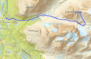
Part II of this account is just a day by day account of what I did on this recent trip and might give some ideas for routes for anyone else interested in skiing in Lyngen. The maps below are screen grabs from the Norwegian national mapping website, and I've just drawn a line on them - it's not a GPS track so only shows approximately the routes I took.

Sunday: Jiehkkevárri (1834 mtrs) via Holmbuktind (1666 mtrs).
 
Jiehkkevárri, taken later in the week from Ellendaltinden. The summit is the central high snow dome. Holmbuktind is the peak on the far left. The traverse between them follows the skyline.

I would imagine this is going to feel like a big day for all but the most ludicrously fit; my friend measured about 2,300 mtrs of ascent. We had a very good avalanche forecast which made the double bowl that is the route up Holmbuktind feel OK. It gets pretty steep in a couple of places, some people took skis off for a short section coming up into the upper bowl, but I felt fine on skis even though I don't have heel bars on my bindings. Leaving the upper bowl and coming out onto the ridge there is another short steep bit, most seemed to take off their skis and I was happy to crampon that bit although some did just in boots. The ridge itself to Holmbuktind is easy enough going up but a serious place to ski coming back down, you wouldn't want to go off either side.

Coming out of the bowls onto the summit ridge of Holmbuktind
From the summit of Holmbuktind you drop down (east) to the col between it and Jiehkkevárri (serious ground on your right). there was one short steeper section a bit after the col that I needed to put crampons on for, but after that its just knackering skinning for another couple of kilometres and some 200 mtrs of ascent to the summit. All of this is a glacier but we saw no signs of crevasses or bergschrunds.
Skiing back across the Jiehkkevárri across the plateau
 You reverse the route to descend. Going back up to the summit of Holmbuktind is pretty morale sapping but the ground gets too steep too quickly to try and take a traverse line below its ridge. Coming off the ridge and back down into the bowl there is probably the steepest bit - my experienced team mates estimated at 35 degrees. They swooped down it being good skiers. Being mediocre, I side slipped which was fine. After that its was all pretty fantastic skiing on spring snow right back down to the last kilometres through the afternoon gloop in amongst the trees. I fell over a lot here and used many rude words, taking skis off though is no help as you'll go crotch deep into the hell-snow. Trying to keep a sense of humour is probably the most important thing and tell yourself its only another few hundred metres back to the car!

Big drops either side - careful skiing back down Holmbuktind's summit ridge.

Fantastic skiing above the sea.

The last of the great spring snow, back down to the trees.


Monday: Middagstinden (1072 mtrs). 


Middagstinden from the house we stayed in.


Steep skinning, Piggtinden's summit behind.
 This hill was right behind our house so an easy target after a long morning of drinking coffee and recovering from the big day before. Considering that this is still about a 1000 mtrs of ascent, we seemed to shoot up Middagstinden; I think we were up and back down in under three hours. Once out of the trees it's a pretty steady ascent up the west flanks. If you keep towards the ridge (south) you both minimise being on open slopes and get great views over to Piggtinden and it's amazing ridge. Skiing down was fantastic on first powder then great, firm spring snow. Once back in the trees I found what must be a track in summer and followed that back down coming out right by our house, avoiding the difficult slush skiing through the trees that had finished the day before.


Looking back up at the great slopes we descended.

Tuesday: rest day.  

Heavy rain at sea level. Some of us went to Tromsø for some shopping. I visited the the North Norway Art Gallery which was both interesting and free!
They grow 'em tough up north.


Wednesday: the lower slopes of Blåtinden. 


Blåtinden from the lower slopes.
Some of the team went fishing in the morning rain, so after lunch myself and the fellow telemarkers of our group, Olli and Mikko, decided to go and check out the skiing conditions. Blåtinden isn't strictly part of Lyngen, its a well known ski peak in the Tromsø Fastland area, but only about 15 minutes from where were staying. We went light without axes or crampons and this meant we thought the upper slopes looked uninviting: either wind-scoured and icy or loaded with the fresh snow that had fallen in the last two days and blown in the hard wind from the now scoured areas. We figured that all the rain at sea level was fresh snow up high and it would have been moved a lot by the strong winds and therefore we wouldn't be missing much besides slog and possible windslab risk higher up. Nevertheless we met the unsuccessful fishermen, Dave, Okke and Roger, as we headed down and they went all the way up reporting that actually the conditions on the upper half were fine. Oh, well - a summit for another time.

Above Balsfjord.

Olli making tracks down next to our track up.

Thursday: Tomastinden South Summit (c. 1525 mtrs).

Tomastinden in the evening light. Don't worry you don't go up from that side!
 The route finding is pretty easy on this one, from Lakselvbukt you go straight up the bloody, big couloir above the village (Tomasrenna). This we found mainly skiable although we bootpacked maybe the last couple of hundred metres. From here you emerge on to a wonderful glacial plateau, nicknamed the 'place of heavenly peace' surrounded by the Lakselvtindane peaks.
The skin track in up the Tomasrenna

The wonderful 'Place of Heavenly Peace'
With the other telemarkers again I headed to the south summit of Tomastinden which appears to be the regular "skiers peak" - the actual summit is a few metres higher at 1554 but would require climbing gear to reach. Skiing back down from this peak was great in powdery snow then a schuss back across to glacier to the top of the Tomasrenna. I realised coming up that this was going to be beyond my skiing skills on the return, so I cramponed down the first few hundred metres before going back to skis. For strong skiers in our party this was amongst their favourite bits of skiing on the trip. For me, it was a bit to tough going to be really fun, but there is some satisfaction to be gained in just doing something difficult for you, and doing it safely.
A Norwegian skier dropping down from Tomastinden's south summit

Olli and Mikko skiing back down the Tomasrenna.

Friday: Ellendaltinden (1345 mtrs).

Ellendaltinden (centre) and Langsdaltindane (right) from Tomastinden. The approach goes up the valley between the two.
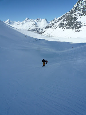
After the 'big thursday', the Telemark team decided maybe to try something a bit easier for Friday. In one sense Ellendaltinden was difficult. Most of the skiing was straightforward although the last summit cone was covered in thick, hard sastrugi, so we left our skis at the col and bootpacked the last bit. But on the other hand, whilst beautiful, it was a long ski up Ellendalen - probably the the most distance we covered all week. 
The valley approach starts along snowmobile tracks.

Higher, looking back down and westwards.

The mighty north wall of Langsdaltindane, around 700 mtrs high.
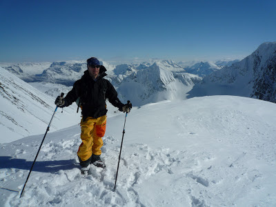
 On the return a lot of this is just schussing, and in the afternoon sun we even had to pole a bit on the flatter sections. Nevertheless, its a fantastic viewpoint and you can seen right across Lyngen, and back in land to Sweden and Finland from the summit. Again, here the skiers summit is slightly lower than the true summit, but perhaps on by a metre or two; and getting over to the true summit looks really rather tricky!
Swinging round to climb westward up the open easy summit slopes; great skiing coming back down.

Mikko on the summit, looking south into the valleys that go up to Sweden and Finland.

Hiking back down to the col where we left our skis.
After six days of great skiing, everyone back down safely. Enjoying a beer in the afternoon sunshine. Thanks guys for the great trip!